Waterwatch Data Portal
Waterwatch Site Search
52 results found (Displaying 26 - 50)
| Site code | Name | ||
|---|---|---|---|
EG_MOR090 |
Macleod Morass - OutletInactive Pond/Wetland 24_4 Mitchell River 21-03-1996 - 18-08-2014 339 Site visits

|
||
EG_MOR070 |
Macleod Morass - Quadrat 1 Carp Research StationInactive Other 24_4 Mitchell River 29-06-1998 - 10-07-2002 63 Site visits |
||
EG_MOR091 |
Macleods Morass below bridge/salt gateInactive Creek 24_4 Mitchell River 23-06-2014 - 18-08-2014 3 Site visits |
||
EG_MMS010 |
McMillan Strait - Raymond IslandInactive Estuary 24_4 Mitchell River 04-01-1997 - 08-03-2011 623 Site visits |
||
EG_BDL010 |
Middle CrkInactive Creek 24_4 Mitchell River 0 Site visits |
||
EG_BDL009 |
Middle Crk closer to Reid PropetyInactive Creek 24_4 Mitchell River 0 Site visits |
||
EG_MIT280 |
Mitchell River " private jetty between cliffs & Morass"Inactive River 24_4 Mitchell River 27-02-2009 - 18-08-2014 19 Site visits
|
||
EG_MIT055 |
Mitchell River 'Old JettyInactive River 24_4 Mitchell River 22-02-2012 - 26-01-2015 28 Site visits
|
||
EG_MIT062 |
Mitchell River - Wharf @ 2mInactive Other 24_4 Mitchell River 04-02-2001 - 22-04-2007 241 Site visits |
||
EG_MIT070 |
Mitchell River - 34 Robb StreetInactive Other 24_4 Mitchell River 30-06-2000 - 09-03-2002 6 Site visits |
||
EG_MIT071 |
Mitchell River - 34 Robb Street @ 1mInactive Other 24_4 Mitchell River 11-02-2001 - 09-03-2002 2 Site visits |
||
EG_MIT072 |
Mitchell River - 34 Robb Street @ 2mInactive Other 24_4 Mitchell River 11-02-2001 - 09-03-2002 3 Site visits |
||
EG_MIT073 |
Mitchell River - 34 Robb Street @ 3mInactive Other 24_4 Mitchell River 13-08-2000 - 09-03-2002 3 Site visits |
||
EG_MIT074 |
Mitchell River - 34 Robb Street @ 4mInactive Other 24_4 Mitchell River 11-02-2001 - 11-02-2001 1 Site visits |
||
EG_MIT540 |
Mitchell River - Lind BridgeActive Other 24_4 Mitchell River 25-10-1999 - 17-08-2019 15 Site visits |
||
EG_MIT543 |
Mitchell River - Lind Bridge at 3mInactive Other 24_4 Mitchell River 25-10-1999 - 25-10-1999 1 Site visits |
||
EG_MIT090 |
Mitchell River - Mouth of Silt Jetties @ surfaceInactive Estuary 24_4 Mitchell River 12-01-1998 - 19-08-2014 46 Site visits
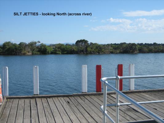
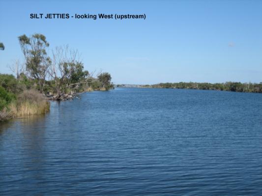
|
||
EG_MIT050 |
Mitchell River - Old Bairnsdale PortInactive Other 24_4 Mitchell River 05-06-1998 - 14-03-1999 10 Site visits |
||
EG_MIT051 |
Mitchell River - Old Bairnsdale Port @ 1mInactive Other 24_4 Mitchell River 14-03-1999 - 14-03-1999 1 Site visits |
||
EG_MIT040 |
Mitchell River - Picnic PointInactive Other 24_4 Mitchell River 02-03-2000 - 02-03-2000 1 Site visits
|
||
EG_MIT041 |
Mitchell River - Picnic Point @ 1mInactive Other 24_4 Mitchell River 02-03-2000 - 02-03-2000 1 Site visits |
||
EG_MIT060 |
Mitchell River - WharfInactive Other 24_4 Mitchell River 01-04-2000 - 05-08-2007 321 Site visits |
||
EG_NLA050 |
New Lands Arm "Dawsons Cove boat ramp"Inactive Estuary 24_4 Mitchell River 16-12-2008 - 11-06-2015 61 Site visits
|
||
EG_JON010 |
Over Zostera Meadow - Jones BayInactive Other 24_4 Mitchell River 11-03-1998 - 08-05-2002 51 Site visits |
||
EG_PAY010 |
Paynesville Canal, Burrabogie Bridge - Site 2Inactive Other 24_4 Mitchell River 26-02-1999 - 25-09-2012 14 Site visits
|
||

All content, files, data and images provided by the Waterwatch Data Portal and Gallery are subject to a Creative Commons Attribution License
Content is made available to be used in any way, and should always attribute Waterwatch and www.vic.waterwatch.org.au
.png)