Waterwatch Data Portal
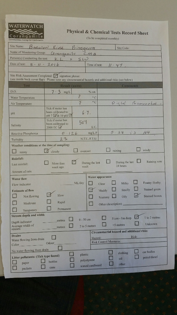
CO_BAR020 Barwon River@Birregurra above Birregurra-Deans Marsh Road
Site details
Overview
| Site code | CO_BAR020 |
|---|---|
| Site name | Barwon River@Birregurra above Birregurra-Deans Marsh Road |
| Status | Active |
| Water Authority | Corangamite |
| Basin | Barwon River |
| Catchment | Barwon River |
| Sub catchment | Barwon River |
| Reach | 33_5 Barwon River |
| Water type | River |
| Council | |
| History | View all 223 site visits 18-07-1995 - 15-12-2023 |
| Monitoring organisations |
Site visits
 Loading chart
| Date | D.O. % | D.O mg/L | eDNA presence=1 | EC µS/cm | pH pH Units | rP mg/L P | Suspended Solids mg/L | Air ° C | Water ° C | P mg/L | Turb FTU | Turb NTU |
|---|---|---|---|---|---|---|---|---|---|---|---|---|
| 23-10-2022 | 442 | 7 | 16 | |||||||||
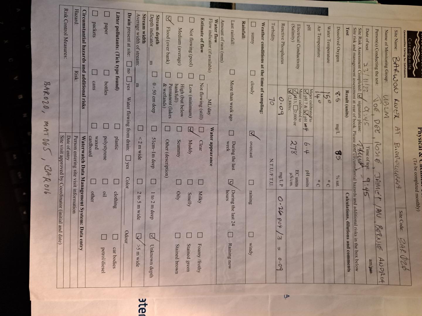
| 23-11-2022 | 84.37 | 8.5 | 278 | 6.4 | 0.09 | 14 | 15 | 70 | ||||
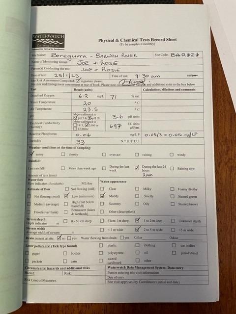
| 25-01-2023 | 68.33 | 6.2 | 697 | 0.016 | 23.5 | 20 | 33 | |||||
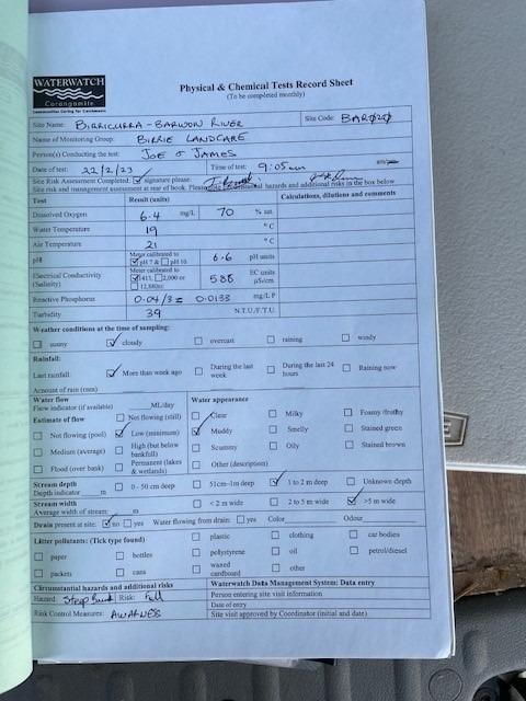
| 22-02-2023 | 69.11 | 6.4 | 588 | 6.6 | 0.013 | 21 | 19 | 39 | ||||
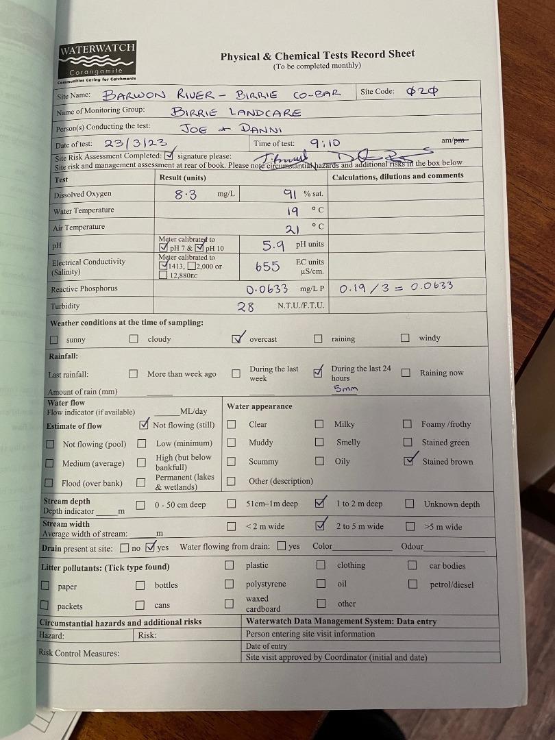
| 23-03-2023 | 89.65 | 8.3 | 655 | 0.063 | 21 | 19 | 28 | |||||
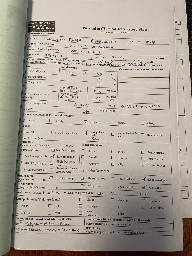
| 20-04-2023 | 82.62 | 8.3 | 1193 | 6.2 | 0.083 | 16 | 15 | 36 | ||||
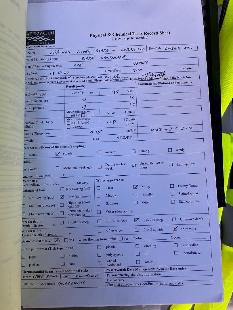
| 18-05-2023 | 95 | 10.4 | 728 | 7 | 0.15 | 13 | 10 | 24 | ||||
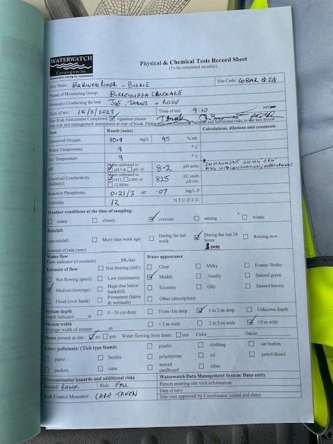
| 18-08-2023 | 94.55 | 10.9 | 825 | 8.2 | 0.07 | 9 | 9 | 12 | ||||
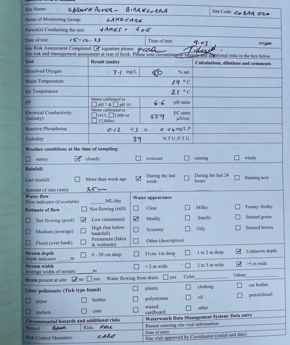
| 15-12-2023 | 76.67 | 7.1 | 559 | 6.6 | 0.04 | 21 | 19 | 39 |
Habitat
| Date | Comment | Bank Erosion Stability | Bank Vegetation | In Stream Cover | Riffles Pools Bends | Verge Vegetation | Overall |
|---|---|---|---|---|---|---|---|
| 14-09-2019 | Poor 2 | Poor 4 | Poor 4 | Fair 3 | Poor 4 | 17 | |
| 22-09-2018 | Poor 2 | Fair 6 | Good 8 | Fair 3 | Poor 4 | 23 | |
| 30-03-2017 | Fair 3 | Poor 4 | Good 8 | Good 4 | Poor 4 | 23 | |
| 18-01-2011 | poplars on both sides - ocasional willow, some eucalyptus - lots of orb spiders - poas on bank | Fair 3 | Fair 6 | Fair 6 | Poor 2 | Good 8 | Fair 25 |
| 20-01-2010 | Good 4 | Good 8 | Poor 4 | Fair 3 | Good 8 | Fair 27 |


All content, files, data and images provided by the Waterwatch Data Portal and Gallery are subject to a Creative Commons Attribution License
Content is made available to be used in any way, and should always attribute Waterwatch and www.vic.waterwatch.org.au
.png)