Waterwatch Data Portal
Site details
Overview
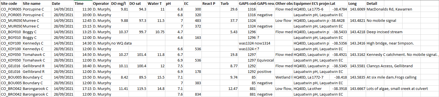
| Site code | CO_GEL016 |
|---|---|
| Site name | Gellibrand River Clancys Access |
| Status | Active |
| Water Authority | Corangamite |
| Basin | Otway Coast |
| Catchment | Gellibrand River |
| Sub catchment | Gellibrand River |
| Reach | 35_15 Gellibrand River |
| Water type | River |
| Council | |
| History | View all 4 site visits 12-11-2015 - 29-10-2022 |
| Monitoring organisations |
|
Site visits
 Loading chart
| Date | D.O. % | D.O mg/L | eDNA presence=1 | EC µS/cm | pH pH Units | Reactive Phosphate (ppb) ppb | Water ° C | Turb NTU |
|---|---|---|---|---|---|---|---|---|
| 29-10-2022 | 117 | 6.8 | 0.02 | 120 |


All content, files, data and images provided by the Waterwatch Data Portal and Gallery are subject to a Creative Commons Attribution License
Content is made available to be used in any way, and should always attribute Waterwatch and www.vic.waterwatch.org.au
.png)