Waterwatch Data Portal
Site details
Overview
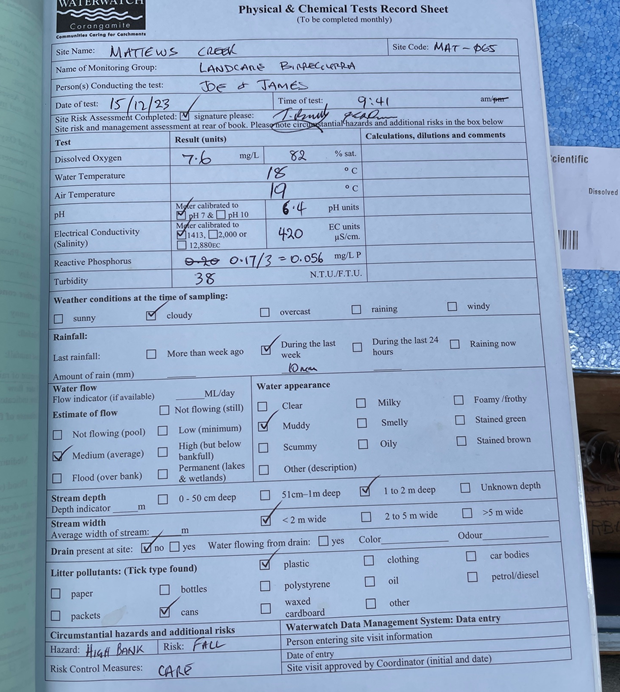
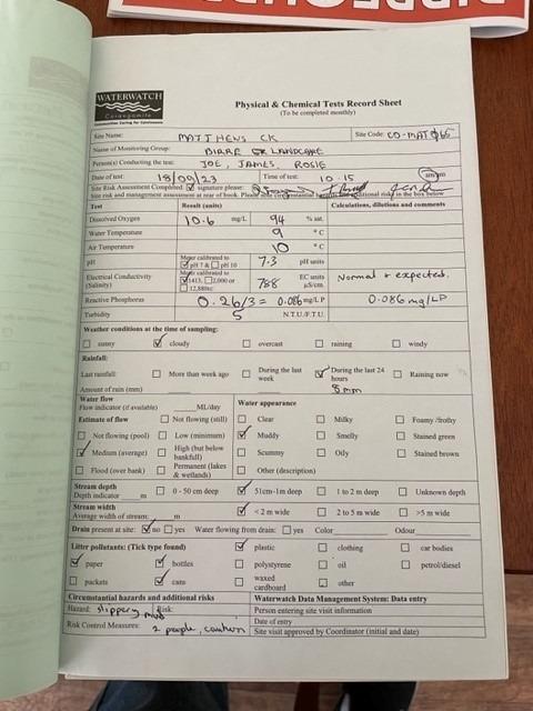
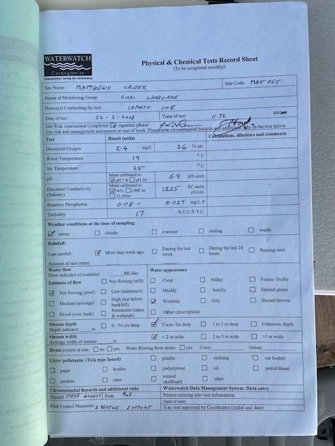
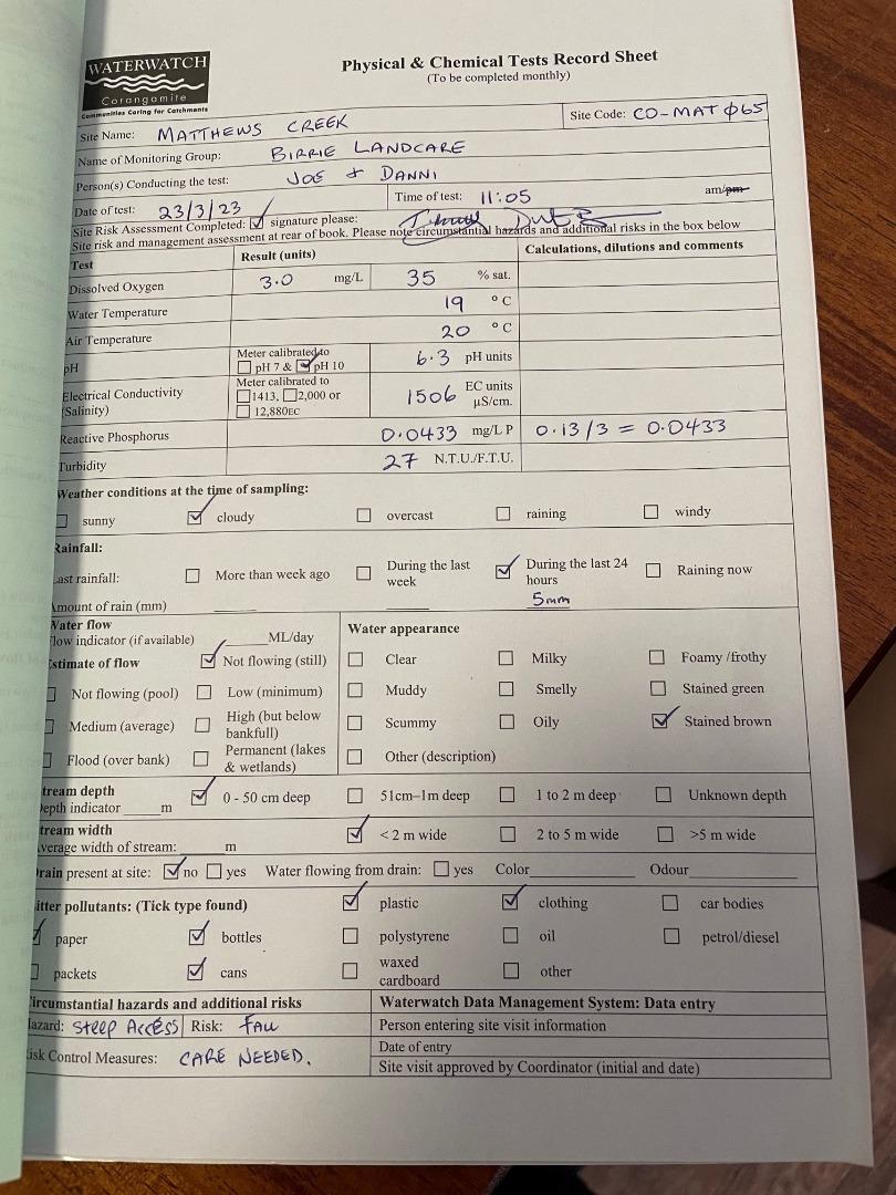
| Site code | CO_MAT065 |
|---|---|
| Site name | Mathews Creek @ Deepdene |
| Status | Active |
| Water Authority | Corangamite |
| Basin | Barwon River |
| Catchment | Barwon River |
| Sub catchment | |
| Reach | |
| Water type | Other |
| Council | |
| History | View all 119 site visits 04-07-2007 - 15-12-2023 |
| Monitoring organisations |
Site visits
 Loading chart
| Date | D.O. % | D.O mg/L | eDNA presence=1 | EC µS/cm | pH pH Units | rP mg/L P | Air ° C | Water ° C | Turb FTU | Turb NTU |
|---|---|---|---|---|---|---|---|---|---|---|
| 22-02-2023 | 25.97 | 2.4 | 1225 | 6.9 | 0.027 | 25 | 19 | 17 | ||
| 23-03-2023 | 32.49 | 3 | 1506 | 6.3 | 0.043 | 20 | 19 | 27 | ||
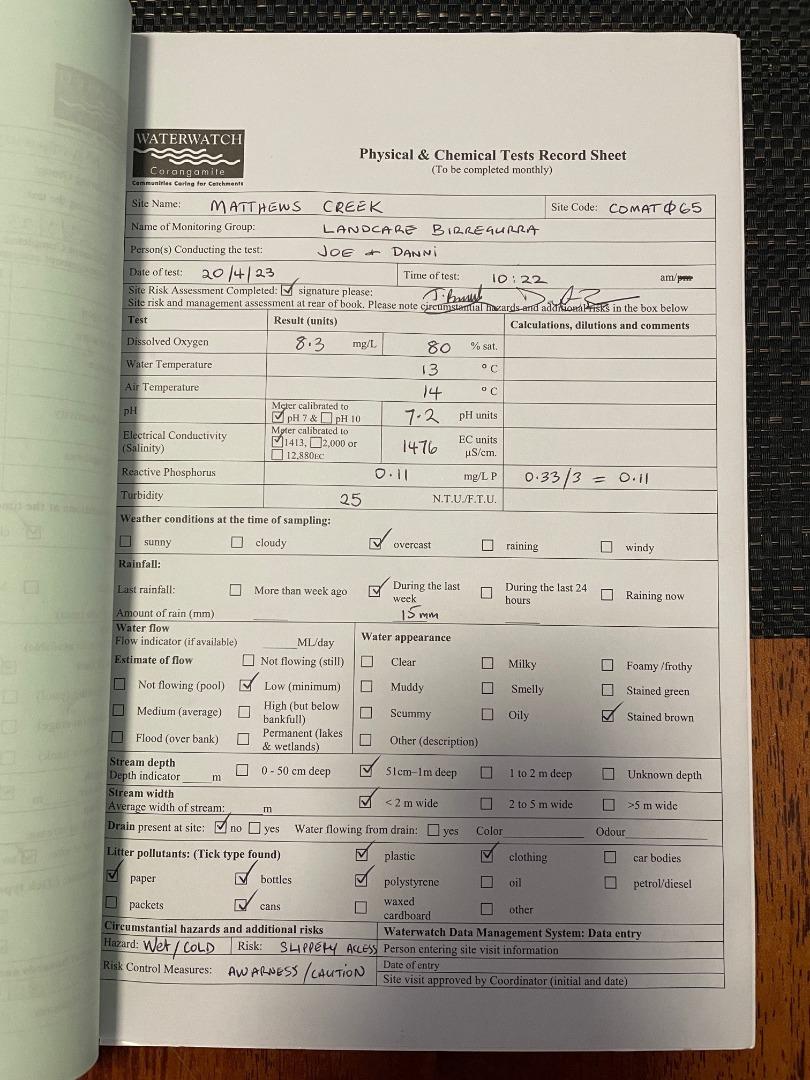
| 20-04-2023 | 79.14 | 8.3 | 1476 | 7.2 | 0.11 | 14 | 13 | 25 | ||
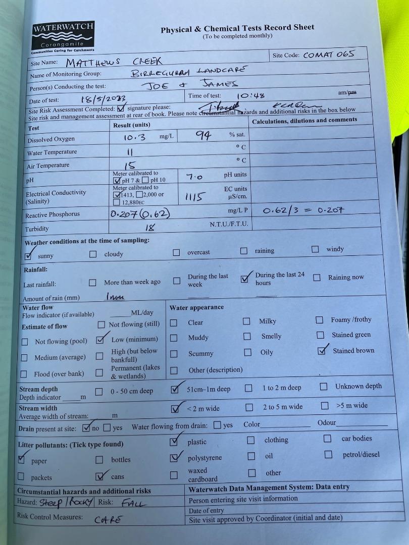
| 18-05-2023 | 93.74 | 10.3 | 1115 | 7 | 0.207 | 15 | 11 | 18 | ||
| 18-08-2023 | 91.93 | 10.6 | 788 | 7.3 | 0.086 | 10 | 9 | 5 | ||
| 15-12-2023 | 80.38 | 7.6 | 420 | 6.4 | 0.056 | 19 | 18 | 38 |
Habitat
| Date | Comment | Bank Erosion Stability | Bank Vegetation | In Stream Cover | Riffles Pools Bends | Verge Vegetation | Overall |
|---|---|---|---|---|---|---|---|
| 14-09-2019 | <p>Platypus eDNA site</p> <p>Burrowing Habitat Score 2</p> <p>Site Result Negative</p> | Poor 2 | Fair 6 | Fair 6 | Fair 3 | Poor 4 | 21 |
| 22-09-2018 | Good 4 | Poor 4 | Good 8 | Poor 2 | Fair 6 | 24 | |
| 04-07-2011 | Survey conducted by Gene | Poor 2 | Poor 4 | Fair 6 | Poor 2 | VeryPoor 2 | Poor 16 |
| 08-06-2010 | pasture grasses, reeds, some reveg (eucalypts) | Fair 3 | Fair 6 | Good 8 | Good 4 | Good 8 | Poor 29 |
| 01-07-2009 | gorse, blackberry | Good 4 | Good 8 | Good 8 | Fair 3 | Excellent 10 | Poor 33 |
| 04-06-2008 | gorse, cocksfoot, exotic pasture weeds, blackwoods, native aquatic plants, blackberries | Good 4 | Excellent 10 | Good 8 | Good 4 | Excellent 10 | Poor 36 |
| 04-07-2007 | some poa lab, phalaris, phragmites, few blackwoods. Road construction adjacent and CMA rock shutes | Fair 3 | Good 8 | Fair 6 | Good 4 | Good 8 | Poor 29 |

All content, files, data and images provided by the Waterwatch Data Portal and Gallery are subject to a Creative Commons Attribution License
Content is made available to be used in any way, and should always attribute Waterwatch and www.vic.waterwatch.org.au
.png)