Waterwatch Data Portal
Site details
Overview
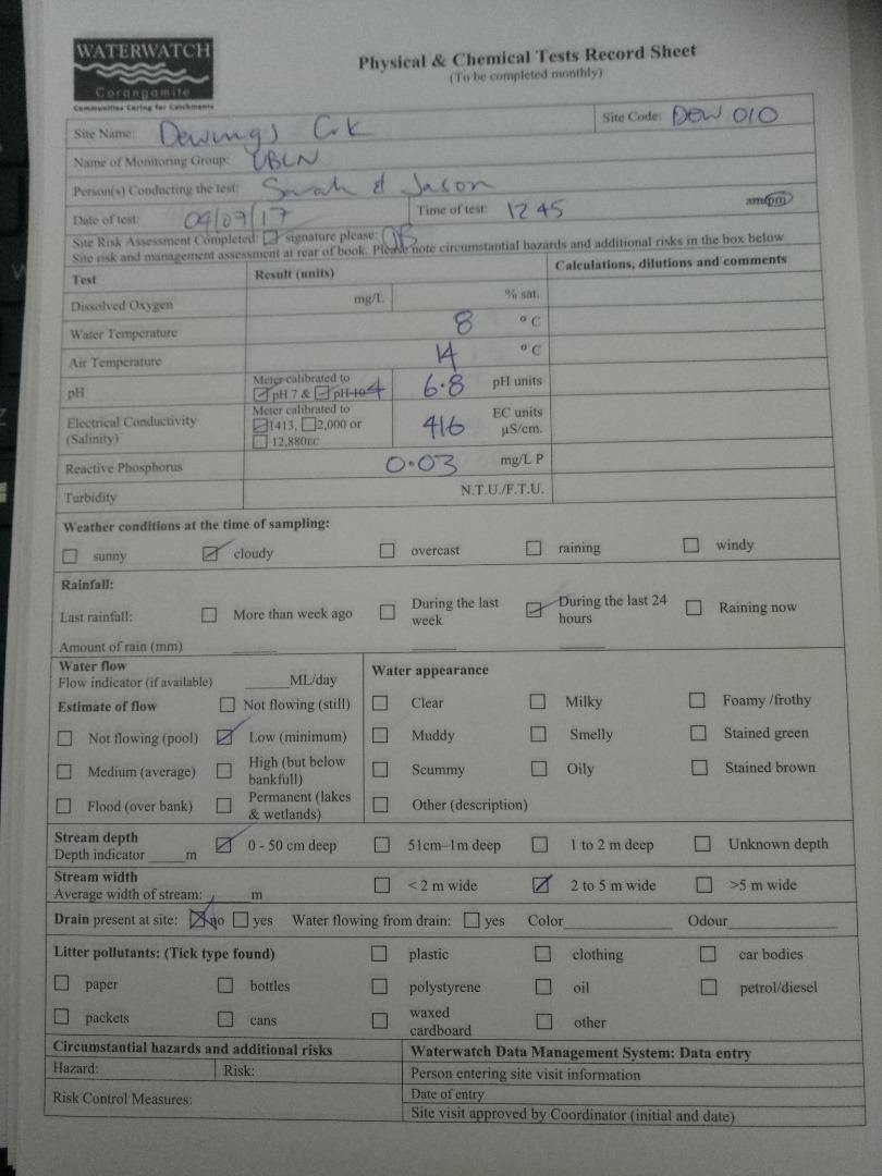
| Site code | CO_DEW010 |
|---|---|
| Site name | Dewings Creek |
| Status | Inactive |
| Water Authority | Corangamite |
| Basin | Barwon River |
| Catchment | Barwon River |
| Sub catchment | |
| Reach | 33_25 Dewing Creek |
| Water type | Other |
| Council | |
| History | View all 115 site visits 14-06-2007 - 07-05-2021 |
| Monitoring organisations |
|
 Loading chart
Habitat
| Date | Comment | Bank Erosion Stability | Bank Vegetation | In Stream Cover | Riffles Pools Bends | Verge Vegetation | Overall |
|---|---|---|---|---|---|---|---|
| 05-06-2020 | <p>Platypus eDNA Site</p> <p>Burrowing Habitat Score 2</p> <p>Site Negative</p> | Poor 2 | Poor 4 | Fair 6 | Fair 3 | VeryPoor 2 | 17 |
| 22-09-2018 | Poor 2 | Poor 4 | Fair 6 | Fair 3 | Poor 4 | 19 | |
| 04-07-2011 | Survey conducted by Gene. North West. | Poor 2 | VeryPoor 2 | Poor 4 | Poor 2 | VeryPoor 2 | Poor 12 |
| 08-06-2010 | willow, exotic grasses, exotic trees | Fair 3 | Good 8 | Fair 6 | Good 4 | Good 8 | Poor 29 |
| 02-07-2009 | blackberry, willows, | Good 4 | Excellent 10 | Good 8 | Good 4 | Excellent 10 | Poor 36 |
| 05-06-2008 | willows, elms, blackberries, pine tress, exotic grasses, juncus | Good 4 | Good 8 | Fair 6 | Fair 3 | Excellent 10 | Poor 31 |
| 14-06-2007 | willows, exotic grasses, no native veg, unrestricted stock access | Fair 3 | Good 8 | Fair 6 | Good 4 | Good 8 | Poor 29 |

All content, files, data and images provided by the Waterwatch Data Portal and Gallery are subject to a Creative Commons Attribution License
Content is made available to be used in any way, and should always attribute Waterwatch and www.vic.waterwatch.org.au
.png)